| Cres |
| Plitvice |
| Lokrum |
| Cavtat |
| Mljet |
| Susak |
| Osijek |
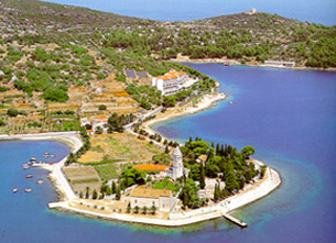
| Vis |
| Vukovar |
| Ilok, Aljmas |
| Vukovar reg. |
| Bol |
| Brijuni |
| Bol, Skrip |
| Nin |
VIS - LISSA - ISSA
Holidays 1999 and the visit to BLUE CAVE on Bisevo Island
Zvonko Springer,
Salzburg, Austria, 1999
on this web with kind permission, 2005
At age of 7 years (1932) I spent the summer holidays with my family on the Island of Korcula (pronounce Korchulah). My mother made a boat trip visiting the BLUE CAVE on Island of Bisevo (Bishevo). Despite a rather clumsy boat trip my mother returned rather excited to Korcula due to her visit to that extraordinary grotto. She said to me: "When you grow up you MUST see this most beautiful Blue Cave!" Only after 67 years I was able to follow up mother's recommendation. As a visitor or tourists (particularly a foreigner) one had to have a police permit for touring the Islands of Vis and Lastovo during the times of Yugoslavia.
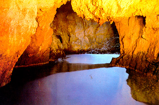
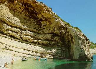
A postcard picture of the "Blue Cave" on Bisevo island.
In the recent history, Italians occupied Vis on 23.04.1941
soon after Germans started the war against the Kingdom of Yugoslavia.
The fascist regime in Italy capitulated on 08.09.1943 and a month later
Italy even declared a war against Nazi Germany. In the meantime a
partisan war raged in several regions of late Yugoslavia. Josip Broz
Tito got support from the British government first followed by the
American and the Russian one at last. British commando and naval units
helped Tito's insurgents to capture the island of Vis and defending it
successfully against German subsequent attacks. In November 1943 Tito
moved his HQ to Vis (Tito's cave is a tourist attraction nowadays).
Soon hundreds of refugees and wounded soldiers from the mainland
flooded the island. The museum of Vis keeps several proclamations of
Tito's temporary government some containing orders of recruitment into
the National army of all males aged 15 to 50 years. The remaining
population consisting of woman and children, elderly people and wounded
refugees from occupied territory had to leave or were evacuated to the
ill-reputed El Shat camp in Egypt. Many didn't returned from this exile
though.
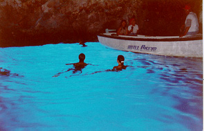 |
| The "Blue cave" during author's visit on 4.9.1999. |
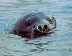 |
| The monk seal is still anxiously awaited. |
During our holidays to the island of Vis in summer 1999 I shouldn't have to miss the opportunity visiting the neighboring island of Bisevo as a permit isn't needed in the Republic of Croatia now. Local fishermen knew about the "BLUE CAVE" on Island of Bisevo since ancient times. It's also called the "Medvidina spilja" (= bear's grotto) as it used to be the habitat of monk seal - a rare sea mammal. Baron Eugen Rausoonet rediscovered it in 1884. The cave is 24m long, 10 to 12m wide, up to 15m high and deep up to 16m at some places. The entrance is a narrow corridor, which is 1,5m high and 2,5m wide only, being the only access into the cave itself. The sun enters into the cave's interior through an under sea's opening shimmering on cave walls in an entire spectrum of colors with always dominating blue hue. Silvery drops glitter on brownish limestone walls all over where as the light diffracts in the sea creating a wondrous silvery glow. There's an underwater bridge at a depth of some 6m deep halfway inside the cave that it is dividing into two chambers. Local boatsmen take groups of say 10 visitors each into the cave through that corridor for a stay say 20 minutes or so. One enters coming from outside's bright sunshine into a luminescent cave's interior where few brave ones could have a dip in a pretty cold sea. Make sure that your visit to the cave is at about 11 o'clock and at bright sunshine, as clouds would spoil the luminescence.
The geography of Vis Island
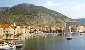
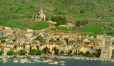
Island of Vis belongs to the central Dalmatia archipelago. Its area of 90,3 km2 is mostly mountainous configuration (it highest peak is Hum at 587m ASL) between which there are several dolinas or poljas (= fields). The zenith of island's population was 10,107 in 1910, dwindling to 8,756 during the worldwide recession in 1930s that continued even more after the WW2 to the minimum of 4,175 by 1981. Now, there are hopes that more young people would return to Vis augmenting its present population of some 7,000. This would help to improve island's economy after a very long decline and sustain development of tourism too.
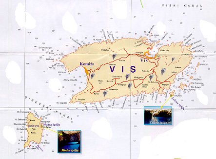
A touristic and sailing map showing the islands of Vis and Bisevo (lower left).
Vis is the native island of vinifera grapes brought here by the Greeks. After the recent island's depopulation the vineyards deteriorated rapidly and are either choked with rank vegetation or show as infertile bottommost. There are many carob-trees (St. John's bread trees) that grew untroubled and without any harvesting for years. The trees expanded without control and one could have an abundant harvest for which there is no usage. There is one mill in Komiza producing the powder of St. John's bread but who wants to make cakes or bread out of it today? Even the honey from Komiza has the distinctive taste of carob-tree that mixes with that of rosemary or garden-sage depending upon its harvest time.
The island of Vis was always domicile of
laborers, seamen and fishermen faithful to the soil and the sea as
well. In Komiza one can see ruins of late salty fish manufacture and
lobster nurture ("jastozara") for the export. There's a new
sardine-in-tin manufacturing plant that works sporadically due to the
scarcity of fish now. The climate is pleasant sunny one about the whole
year round. The tiny islet of Bisevo with many magnificent grottos is
not far away and of them is the famous "Blue Cave" too. Along island of
Vis cost line there are many traces of tectonic activities and its
volcanic past that formed many gorges, narrow canyons or gullies,
weathered and/or re-crystallized rocks etc. From Vis northern shores
the flinty sand for glass manufacture was exported to Venice and
Syracuse on Sicily Island.
 |
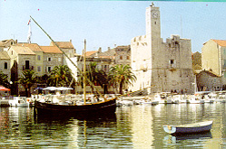
| The harbor of Komiza with the fortress "Kula". |
 |
|
The native boat "Faltusa" in the
harbour.
|
The two most distant islands Brusnik and
Jabuka are of volcanic origin too. From their geological origin derives
the shores dark coloration, which is the habitat of a very rare black
lizard too. Brusnik pinnacle is only 12 meters above the sea level and
has numerous gravel coves. The other island Jabuka is smaller but 96
meters high and looks like a black pyramid seen from afar. Palagruza is
the most southern island in the Croatian Sea, along which shores of
white pebbles excellent capers are caught being a true gourmet
delicacy. One used to make weapons and tools sharp points of the
volcanic rock of Brusnik and Jabuka.
The bay of Stiniva with typical rock
formation at the south coastal line of Vis.
Vis is one of the rare Adriatic islands having its own soft water underground reservoirs. The present island's water supply uses two deep wells from which the water is pumped to high intermediary tanks from the general supply all over the island itself. One haven't established yet whether the underground reservoirs are in any connection with the mainland through undersea siphons common in the karst (= chalk) regions of Croatia. At the eastern part of the "Komiza Zaliv" (= bay) there is a smaller bay named "Kamenica" where one can find full relaxation. This is a secluded gravel beach with shade giving trees and fresh water springs. A legend associates these two springs just below the hill of Muster to another one on western part of the Komiza Bay.
Interlude: Long time ago pirates were regularly visiting the Komiza town forcing its inhabitants to flee finding a refuge in the fortified church on nearby hill of Muster. On such a visit of looting pirates took away a 1,5m wooden statue of St. Mary from the small church at western part of Komiza Bay. A very strong wind rose up with high rollers preventing pirates of sailing out of the bay. They got very scared and dropped over board the statue as first. When the danger of pirates ceased few days later the islanders found the statue stranded at Kamenica bay. With great celebration they took the statue bringing it back to the original place. But they noticed too that a strong spring of fresh water sprouted where the statue was washed on shore. Happy about this good news (this spring still exist today) the procession moved St. Mary's statue back to the other bay's end to find that another spring of fresh water shoot up there too. The islanders used these springs until recently, when the one of them was covered (sealed) next to the church with the rescued St. Mary statue still there. Thus this church is named as "Our Lady of Pirate" today. Island's romantic loneliness, being lost far away on the high seas and surrounded by the silent sea, the island of Vis still remembers its very long past.
The church of St. Nicolas on the hill of Muster above the
harbor of Komiza.
The history of Vis Island
The first settlements on Island of Vis originate from the Neolythicum. A new era started around 1,000 BC with the arrival of warriors using more durable iron weapons and tools. These were the Illyrians who lived in hill-forts of which some spread over an area up to 2 kilometres having defence walls up to ten meters high. Their cemeteries were found on the islands of Hvar, Pakleni otoci ("Hell's Islands"), Brac, Korcula and Vis. The Illyrians held the islands from Krk in the north to Vis in the south and the tribe of Liburnians occupied the islands and controlled the anchors around them. Greeks or Helens did not threaten them much, although there are legends (like the one about "Apsyrdites" or "Ogygia") indicating that they were the ones who created the significant Trans European/Mediterranean trade trails.
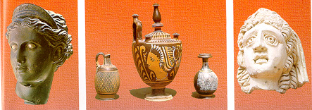
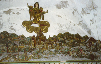
From the domicile
museum of Vis. From left a beautiful head of the goddess Arthemida
(brass and silver), a vase and goblets and a sculputere's head of
marbel.
Helens mention the Adriatic Seas in 7th century BC on their way along the Italian Peninsula that Liburnians were still dominating it. When Helens started creating their own states outside Greece motherland they became interested in the Adriatic islands too. The inhabitants of Syracuse on Sicily founded the city-state of Issa on island of Vis at the end of 4th century. Parallel to it the Ionians, from the island of Paros in Greece, founded the city Pharos on island of Hvar (today's Stari Grad). A naval battles took place between these two neighboring states in 384 BC that is the first recorded armed naval conflict in the Adriatic Seas. The native Illyrian's light ships were loosing battles against the Greek bigger ships too. The appearance of Celts in eastern or Roman in western Adriatic by 4th century BC hardly influenced the Illyrians or Greeks.
The ruler Acron of Ardieian tribe (Illyrian) conquered Greek colonies progressively and reached after the mighty Issa (Vis) too. Rome helped threatened Vis and conquered almost all of Adriatic islands by 228 BC in due course. As Roman vassals inhabitants f Vis maintained their state of Issa, which included both onshore and offshore colonies later. Their economic prosperity was also due to the downfall of rival Pharos' state on Hvar and Illyrians total defeat during the 2nd century BC too. Thereupon the islanders switched more to fishery and agriculture and the fast "Liburnians", the Illyrian prestigious ships, were welcome into the Roman navy. These ships contributed to Augustus Octavian's victory over of his rival Athnonius and queen Cleopatra at the fatal naval battle of 31 BC.
The island of Vis came under total rule of Rome when it was finally subdued in 47 AC. Rome introduced Italic municipal and other laws and gradually granted various privileges so the wine from Vis reached Imperial Rome. The rapid economic recovery went in hand with the substantial construction activities on Vis so a theater and several rustic villas were built for members of the imperial family staying here often. The largest aggregation of some 2,000 roman amphoras was found on the island of Ilovik (south of Losinj) and the largest roman coin sites in town of Osor, on the isthmus between islands of Cres and Losinj.
Towards the end of 6th century AC there are first records of the Slavs' appearance at Istria. One of Slavic tribe named Croatians spread their influence along the entire Adriatic coast and onto the islands. They made the islands and the neighboring mainland in to their new cradle and their ultimate homeland. Soon after their settlement Croatians continued living side by side with the former population but established their own cultural and historical foundations too. Croatian baptizing started by late 7th century AC and completed by the early 9th one already. Emperor Constantin of Byzantium wrote that Croats were baptized under prince Porna (or Borna, 810 - 821). At that time two Croatian states cohabited side by side that were the Primorska and the Posavska Hrvatska. Prince Viseslav's baptismal font (from 9th century) is the eldest religious monument made of beautifully carved stone.
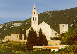
The church of St. Nicolas situated on the hill of Muster.
Interlude: From our hotel in Komiza we
could see a bulwarked church on top of a hill. It turned out to be the
Church of St. Nicolas on the Muster hill. No regular services are held
at this old parish church except one few festive occasions. Such is the
blessing of a fishermen's boat for which a made model of the
traditional FALTUSA (read: faltushah) is carried from the St. Nicolas
church to the Kamenica bay where it's launched and set on fire to burn
down in the sea. One can visit the church only accompanied by the vicar
who acts as its curator and as guide. The local population used this
fortified church as a refuge when the sea pirates attacked Komiza's
fishermen settlement.
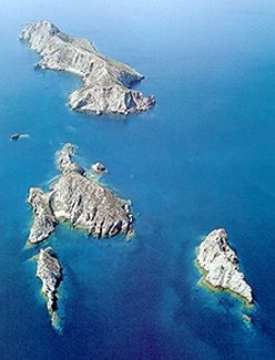 |
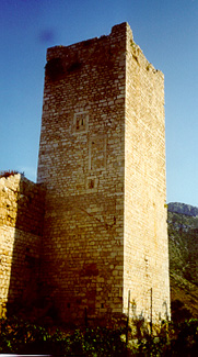 |
| The Palagruza (Pelagosa) group of islands with the important lighthouse at the top one. | The defence tower of the church of St. Nicolas on the hill ofMuster. |
On March 9, 1177 Pope Alexander III. Ships'
convoy set sail from Apulia's small harbor Vieste (located below Monte
Gargano) on Italian Adriatic northern coast. He was to meet Emperor
Frederic I. Barbarossa at Venice with whom he was to make peace and
establish Roman papal authorities again. Sailing with on a good
southerner Pope's faster galleons reached island of Palagruza (Italian:
Pelagosa - 32 sea miles from Vieste) when the wind died out forcing the
fleet to the anchor. The slower ships (with Pope's white horse)
returned to Vieste to try sailing out on next days. Fishemen from
Komiza came with large number of boats (60 - 100 "gajetas" each with a
5-head crew) to Palagruza's grounds for fishing. They met the honorable
guest at the island's only church to St. Michael and served there an
excellent dinner consisting of local specialists, which were duly noted
by the chronologist.
 |
 |
| The church tower of St. Nicolas. | The unique Crib - a wood carved permanent decoration fixed to the wall inside the St. Nicolas Church. |
At the same night Pope's galleons lifted anchor and with a good wind reached Vis harbor (about 45 sea miles) during light next day. According to the tradition Pope's fleet arrived to closer harbor in Komiza first before proceeding to Vis. Fact is that Pope Alexander III. stayed in Komiza to sanctify Benedictines' church of St. Nicolas on Muster and dinned in a simple fisherman's house. Later one was enlarged and still is known as "Pope's house". The stone with engraved text "This house visited Pope Alexander III." was stolen like many other items from that house so it constantly has been refurbished to quench tourists' collection passion.
During the mediaeval times the feudal rulers changed quite often being loyal first to the Byzantium, then to Croatian Kings and Dodges of Venice at times. Venice ruled over Vis from 1420 to 1797 to be followed by the Austro-Hungarian Monarchy until 1805. France governed over Vis for a short while until 1811 to be followed by England until 1814 when the Austro - Hungarian Monarchy took over again its sovereignty over Vis lasting until 1918 i.e. until the end of WW1. Here the Monarchy's fleet won her last naval battle in front of harbor of Vis in July of 1866.
On the morning of July 18 the night watchers on hill of Hum made out the approach of enemy's fleet and alarm sounded in all sea battery forts on Vis. A telegram was rushed to Hvar and proceeded onwards via Split to Pula where was the Monarchy's Adriatic Fleet Command. The Italian mighty fleet under command of Admiral Persano arrived later during the day to Vis after unsuccessful disembark in Komiza bay. Italians started bombarding fortifications Benthinks, Wellington and George as well as batteries of forts Schmidt and Supurine but haven't tried to disembark. During night Italians got substantial reinforcement in ships and soldiers and succeeded to enter into the harbor with 4 ships but 3 of them had to leave due to lack of maneuvering place. The remaining Italian armored cruiser "Formidabile" exchanged severe cannonades with God's Mother battery and few smaller defending ships that caused a lot of smoke and dust constricting the visibility. Despite some severe loses defenders repelled all attacks so Persano ordered his fleet to prepare for the final attack the next day.
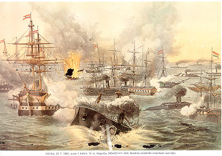
- The lithography of "The Naval Battle of Lissa"on 20.07.1866 by F. Kollarz.
- Property of the Institute of arts and science HAZU in Split.
Defenders' casualties were considerably
smaller and the dead soldiers were buried at the graveyard of Vis where
a monument was erected showing a sleeping lion on a sarcophagus. After
Italian occupation of Vis in 1918 this monument was dismantled and
brought to Italy where it is kept nowadays. The Austrian organization
of World Wars' veterans sponsored the remake of original monument,
which was assembled in Vis in cooperation with the Croatian Navy and
counterpart veterans' organization. Vis domicile museum is under making
in one of the most prominent forts overlooking the whole bay and its
entrance with the islet of Host there.
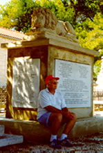 |
 |
| The author at the monument for the fallen defenders of Vis in 1866. | Prirovo - the peninsula at inside the bay of Vis with town's burial place that includes the sarcophagus. |
Sources:
1. CROATIAN ADRIATIC ISLANDS, publishers "LAURANA" and "TRSAT", Zagreb 1996. Text authors: Petar Strcic, Ana Ivelja Dalmatin and Drago Zdunic (concept, selection and design).
2. PAPA ALEKSANDAR III. NA VISU (Pope Alexander III. Visit to Vis) by Martin Oreb, Zbornik HAZU Split, Svezak 4-5, 1993. i 1994. The original scientific paper (in Croatian) by Martin Oreb, 1994.
3. USUSRET ZAVICAJNOM MUZEJU OTOKA VISA (Cretian of Vis domiciled museum), Hrvatski povijesni muzej Zagreb - Arheoloski muzej Split - Grad Vis, 1999. Author: Natasa Matausic (in Croatian).
4. MIT ALLER KRAFT NACH LISSA - Anniversary
exhibition catalogue of the naval battle at Lissa on 18-20 July 1986 on
Vis July - September 1996. Catalogue author: Natasa Matausic (in
German).
DISCLAIMER : On URL: http://www.cosy.sbg.ac.at/~zzspri/ published pages are originals and authorized by copyright of Zvonko Z. Springer, Salzburg 1999.
Email Zvonko Springer at : zzspri@aon.at
Veliki ili Sveti Tjedan na Visu
Croatia - its History, Culture and Science