| Cres |
| Plitvice |
| Lokrum |
| Cavtat |
| Mljet |
| Susak |
| Osijek |
| Vis |
| Vukovar |
| Ilok, Aljmas |
| Vukovar reg. |
| Bol |
| Brijuni |
| Bol, Skrip |
| Nin |
Plitvice lakes
Zvonko Springer, Salzburg, ,Austria, 1999
on this web with kind permission, 2005
I wrote the following lines about a few years ago:
"PLITVICE LAKES region has been liberated during the Croatian police and military action code named "Tempest" early in August 1995. In a concentrated action this region has been cleared of all remaining hostile elements during fall 1995. In this thorough cleaning specialists removed all kind of mines and explosives, arms and other dangerous caches in ground and on surface of the dense forests. All waters in lakes and brooks have been checked too - even many caves (some new ones have been discovered too) as well as all the waterfalls of the Park."
We have visited the NATIONAL PARK PLITVICE after some 40 years since our last visit there. On the way back from our holidays on island Mali Losinj in May of 1998 we decided to visit the Plitvica Lakes region and choose to stay at least for one night at the one of hotels there. Close to the "Entrance 2" there were two hotels working: "Bellevue" and "Plitvica" then. The largest hotel "Jezera" that is closer to the "Entrance 1" was still renovated after severe damages incurred during the Home War. Its reopening is expected by summer 1999.
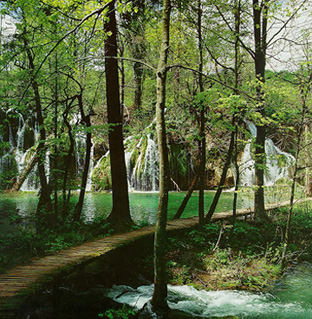
Impressions from the Upper Lakes
From the hotel "Bellevue" we've found best to get onto the open electric-driven streetcar at the "Entrance 2". Following the suggestion that is the best starting the trip from the Upper Lakes as one would be walking mostly downhill to the Lower Lakes at the end. Thus starting from the Upper Lakes we arrived after say 2 hours to the largest of all lakes, the Kozjak Lake. There we boarded one of the several electric driven boats sailing over the Kozjak Lake and enjoying many serene vistas. After about half an hour boat ride we reached the lake's end at Kozjacke Drage and found there a rather large recreation area, a restaurant and several shopping stalls with local food products. From here onwards we continued our walk along the Lower Lakes reaching to the Great Falls of Plitvica River at last. The whole tour takes about 4-5 hours depending upon how much one is harassed by time.

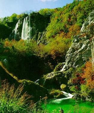
The Lower Lakes are smaller and are squeezed between steep cliffs
forming a gorge.
(Photo by V. Pfeifer from I. Brailic's book on
THE NATIONAL PARKS OF CROATIA)
Now, a short description of our tour that we started at Entrance 2 taking the open electric-driven streetcar open train. After 20 minutes we came to the upper most station at Labudovac Lake from we started walking along the Upper Lakes' rim. First we came up to the Lake Prosce and Ciginovac, strolled around the Lakes Okrugljak and Batinovac, passed between the Veliki & Mali Jovinovac (i.e. the Big & Small Lake) and then coming to the Lakes Galovac, Gradinsko and Burget ("burget" is a local word meaning a small lake or tarn). At Burget Lake we boarded the electric-driven flat boat in which we crossed the largest of all lakes the Kozjak and landed at its western shore at the landing stage Kozjacke Drage. After a short rest there we continued the slow descend along eastern rim of the Lakes Milanovac & Gavanovac. We had to pass here the transverse at the Velike Kaskade (= Big cascade) to the lake's Kaludjerovac West shore. From here starts a light ascent to the largest of all waterfalls in the Plitvica National Park which is the one of Plitvica River.
The return was a bit harder due the route's steep ascent leading to the "Entrance 1". On this route one can enjoy marvelous views down onto the Sastavci and Novakovica Brod, which are the links between the lakes. Splendid are the views of the waterfalls of the Plitvica river as well as those of the Lakes Kaludjerovac and Gavanovac. After wearying ascend we arrived at the northern station of the electric-driven streetcar that is close to the "Entrance 1". We've enjoyed this long and tiresome walk and turned into the nearby "Licka Kuca" (= Lika's House) to have a well deserved rest there including another fine meal too. The night before on our arrival at the Lakes we've enjoyed a perfect dinner of spit barbecued lamb and young onion cum bread only. Superb! After we drove by car to our final destination of the City of Zagreb that took about 2 hours only.
The great waterfalls of Plitvica River
At last I'd like adding some lines about referring to the name of "DEVIL'S GARDEN". The earliest, rather vague, outlines of the lakes are found on maps drawn in the 17th century, where the whole of his area is named as "Devil's Garden". At that time the region of Lika was in Ottoman hands and later the Plitvica area was part of the restless and insecure Military Borderland. The epithet "Devil's" appears understandable although such a name does not seem to have been used by the local population. Here's a legend recorded about a hundred year ago:
"A sultry oppression sat over the fields and mountains for months. People and animals, meadows and gardens yearned for refreshing, gentle rain. The Crna Rijeka (= Black River), an ordinarily a cheerfully babbling stream, dried up. The people's prayers and pleading were all in vein, as the skies showed no mercy on them. But then the Black Queen with her glittering entourage appeared in the valley. The people cried for help, asking for water, without which they would all perish. And the Black Queen took pity on them: with great thunder and lighting, heavy rain began to fall in an instant, bringing life to the people and animals, fields and meadows. The rain poured and poured, and the waters began to grow, until they formed the lakes as we see them today."
Water has always enjoyed a mythical quality, especially in the karst area. And it would be difficult to find more reason and justification for such legends and myths anywhere than here in Plitvica region. Today the Plitvica Lakes are located on one of Croatia's major roads and that instead of a "Devil's garden" the Nature here offers another kind of garden - a abounding in fantastic hydrographic karst phenomena. The gardener - karst - has created many beautiful scenes in Croatia, but nowhere perhaps as beautiful as at Plitvica. The oldest descriptions and more or less precise maps of the lakes are no more than two hundred years old. The first travel lodge (known locally as the Imperial Lodge) was built in 1862 by the border guards, while the first 28 room hotel was built in 1896.
Scientists visited the area for the first time in the early nineteenth century, and the earliest initiative for establishment of a national park to cover the Lake District was made in 1914. Together with several other valuable areas in Croatia, the lakes were proclaimed a national park in 1928. The law to that effect was rather inadequate, providing for its periodic extension (which was not done), so that the national park was not finally and permanently established until 1949. Thirty years later, in 1979, UNESCO placed the Plitvica Lakes on its World Heritage List, thus recognizing its importance for world culture.
The Plitvica Lakes are situated in eastern Lika, between Mala Kapela and Licka Pljesevica Mountains. The two largest lakes take some three fourths of this area: Kozjak - 81.5 hectares and Prosce - 68 hectares. The greatest depths have also been recorded in these lakes: 46 m in Kozjak and 37 m in Prosce. Together with ten smaller lakes between them, these two lakes form the Upper Lakes group. Downstream from Kozjak lie the four Lower Lakes. Many large and small cascades connect the lakes, with the difference in height between the highest (Prosce) and the lowest lake (Novakovica Brod) amounting to 135 meters. The greatest height difference is between Galovac and Gradinsko Jezero and the highest inter-lake waterfalls between Galovacki Buk and Prstavci is 25 meters.
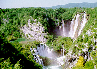
SASTAVCI (= the Connections) - The procession of lakes ends here and the
River Korana begins at the picture's center down. (Photo by V. Pfeifer
from the same book as mentioned before.)
The greater part of lake's water comes from the Crna and Bijela Rijeka's streams (Black & White River) which meet forming the Matica (= Mother River) before entering Proscansko Lake. Lake Kozjak receives Rjecica (a Rivulet) at its southern edge, and out of it flows Korana River. A little below the last lake, there is the 72 meter high waterfall of Plitvica stream which plunges into Korana river with other numerous water cascades at the point called Sastavci (name implies coming together of waters).
Though the Lower Lakes occupy a much smaller area than the Upper Lakes, all natural characteristics of the two groups, especially the landscape features, justify this popularly and scientifically made distinction. The Upper Lakes have dolomite beds (Triassic dolomites), on which surface erosion produces a "normal" relief with the usual stream-made depressions and sloping sides. The terrain around these lakes and parts of the cascade beds are covered with woods.
The Lower Lakes have limestone (Cretaceous) beds and are therefore situated in a canyon cut by a river at a time before the lakes were formed. Though the canyon is not very deep (70 - 80 m), its steep sides give the lakes a special atmosphere and picturesque quality. Lime stones and dolomites come into contact in Kozjak, as one can see at its different shores, with the western, dolomite, shore being much more indented. The Upper Lakes are situated in a richly articulated relief, but the canyon of the Lower Lakes is incised into an undulating plateau that continues down with the Korana River.
The fast growth of travertine is found by comparing first measurements at Plitvica with those made a hundred years later: in 1855. Of these one derives that the lakes and their cascades are very young phenomena. The carbon C-14 isotope dating method shows that the oldest parts of present day cascade beds are no more than 40.000 years old. It has also been established that there was no travertine formation between 6000 and 22,000 years ago.
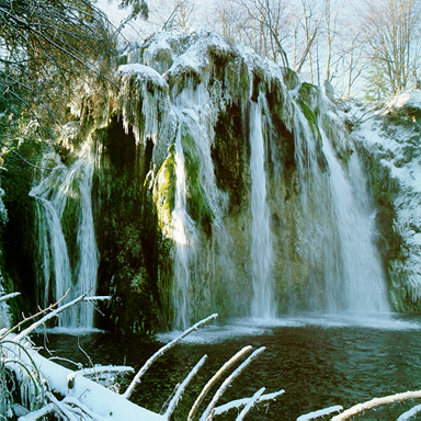
Galovacki Buk in winter - a 16m high waterfall between the Galovacko and
Gradisko Lakes.
(Photo by V. Pfeifer from the same book as mentioned before.)
Travertine of over 40,000 years has been found in Plitvice, in locations above the present cascades and waterfalls. This "old" travertine represents the remains of earlier barriers, formed under favorable temperature conditions that prevailed here during the interglacial period. Travertine is a soft and porous rock (can be cut with an ax, and is also light, thus was often used as construction material); it erodes easily, and the freezing of water in its pores helped to speed up the crumbling process. Thus the canyon itself is a relief form created during the cold periods.
Particular features of Plitvice are caves in travertine cascade beds. They are, of course, much smaller, but they offer an interesting view of the tissue and structure of travertine. Several such caves are found in the waterfall zone, where cascades come down from Prosce and Ciginovac to Okrugljak like Kostelceva Cave (16 x 6 x 6 m) which is found at the upper edge of Plitvica brook waterfall.
Over three fourths of the National Park area is wooded, and the rest is made up of meadows and fields belonging to the villages and hamlets. The forests are crucially important for the survival of the lakes, since much of the forest substratum is dolomite rock. Without the forests, the rocks would quickly erode on the surface and begin to fill the lakes with debris, which would also, damage the fragile cascade beds made of travertine. Such a process has already been responsible for the filling of a small lake at Plitvicki Ljeskovac, which is no longer there now, but which older maps still show. The forests of Plitvice are among the best preserved in Croatia. The main tree varieties are beech, fir, spruce, and scotch pine. The best preserved natural forest complex is found in the Park's northwestern corner, at Corkova Uvala, where - over an area of 80 hectares - there's an almost untouched primeval forest of fir and beech at an altitude of 860 - 1028 m.
The present day settlements Plitvice are only a little over two hundred years old. There is archaeological evidence of occasional habitations even in prehistoric times, during the Yapod (ornaments) and Roman times. There is also evidence of medieval Croatian administrative structures (zupe, districts) and feudal estates belonging to the Kurjakovic and Frankopan aristocratic families (relics of a hospice, church and tower dating from the 12th and 13th centuries at Gradina). Occasional Turkish raids from the 15th century interrupted the continuity of medieval life first onwards. The full-scale Turkish occupation continued throughout the 16th and the greater part of the 17th centuries (until 1689). Even this was not a peaceful period here, as Croatian army units launched frequent attacks and offensives reaching deep into the Ottoman held territory.
DISCLAIMER : On URL: http://www.cosy.sbg.ac.at/~zzspri/ published pages are originals and authorized by copyright of Zvonko Z. Springer, Salzburg 1999.
Email Zvonko Springer at : zzspri@aon.at
Croatia - its History, Culture and Science